WFP Reports Road Access Challenges Across South Sudan Amid Rainy Season
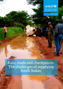
Credit: Relief Web
By Sasuk Taban
The World Food Programme (WFP), through the Logistics Cluster, has released its latest physical road access constraints map, highlighting significant transportation challenges affecting humanitarian operations across South Sudan during the rainy season.
The assessment, published on 17 July 2026, indicates that while many major highways remain passable, numerous secondary and remote roads are either difficult to navigate or completely impassable due to deteriorating conditions, posing serious challenges for the delivery of humanitarian assistance.
According to the report, the Juba–Nimule Highway, one of the country’s busiest transport corridors, remains passable for 40-metric-ton trucks, providing a crucial supply route for commercial goods and humanitarian cargo. Other key routes linking Juba to Lainya, Mangalla, Terakeka and Mundri also remain operational for heavy trucks.
However, access remains severely constrained in several parts of Unity, Jonglei, Upper Nile and the Greater Pibor Administrative Area, where numerous roads have become difficult or impossible to use. Areas around Bentiu, Koch, Leer, Mayendit, Ayod, Akobo and Pibor are among those facing the greatest transportation challenges, increasing the cost and time required to deliver life-saving assistance.
The Logistics Cluster noted that some locations remain accessible only through last-mile delivery using four-wheel-drive vehicles, while specialized trucks are required on certain routes due to poor road conditions.
WFP emphasized that the map reflects only the physical condition of roads and does not account for insecurity, political developments or other factors that may further restrict humanitarian access. The agency also cautioned that road conditions can change rapidly because of heavy rainfall and flooding.
The Logistics Cluster, which is led by WFP, compiles the road access information using data from humanitarian partners including the International Organization for Migration (IOM), the UN Office for the Coordination of Humanitarian Affairs (OCHA), UNOPS, UNMISS, Mission Aviation Fellowship (MAF), GUAL and GeoNames.
Humanitarian organizations rely on the road access assessments to plan the movement of food, medicine and emergency relief supplies to vulnerable communities across South Sudan, particularly during the rainy season when flooding and damaged roads frequently disrupt transport networks.